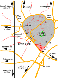
 Brent
Knoll Walks - Walk 5: Circular walk from the Post Office Brent
Knoll Walks - Walk 5: Circular walk from the Post Office
 This
walk of about two miles can easily be completed within an hour.
It contrasts the antiquity of the village with facets of modern
life. Wellington boots are needed in wet weather. The first
part is through a field which can be very muddy, the second
part is on the main A38 Brent Street. This
walk of about two miles can easily be completed within an hour.
It contrasts the antiquity of the village with facets of modern
life. Wellington boots are needed in wet weather. The first
part is through a field which can be very muddy, the second
part is on the main A38 Brent Street.
1. Starting point is Battleborough Lane which leads behind the
Post Office. Continue along this lane for about 200 yards passing
"The Laurels" and some old cottages which butt onto
a field. At the side of the road you will see a deep rhyne.
Such rhynes traverse this area ensuring that flooding is a thing
of the past. Many of the rhynes, dug by hand, are several hundred
years old.
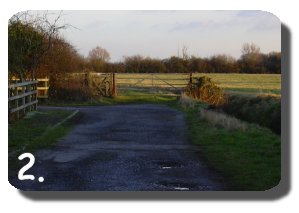 2.
Go through the side gate across a meadow with the lower slopes
of the knoll to the left and the rhyne on your right. Here you
can imagine the battle between the Saxons and the Danes which
took place on these slopes in the ninth century when the Saxons
drove away the invaders from this area, hence the name, "Battleborough
Lane." Note a small and very old stone bridge which gives
access to the field on your right. 2.
Go through the side gate across a meadow with the lower slopes
of the knoll to the left and the rhyne on your right. Here you
can imagine the battle between the Saxons and the Danes which
took place on these slopes in the ninth century when the Saxons
drove away the invaders from this area, hence the name, "Battleborough
Lane." Note a small and very old stone bridge which gives
access to the field on your right.
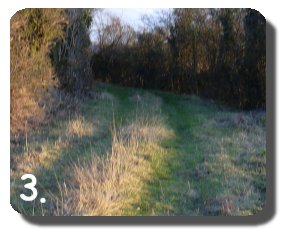 3.
Continue along by the side of the rhyne, go through the gate
which leads onto a "permitted" path. A notice will
tell you of this. This lane leads onto a hard surface which
comes out onto the A 38 main road. On this lane you will see
a variety of homes, one of which resembles an old chapel. 3.
Continue along by the side of the rhyne, go through the gate
which leads onto a "permitted" path. A notice will
tell you of this. This lane leads onto a hard surface which
comes out onto the A 38 main road. On this lane you will see
a variety of homes, one of which resembles an old chapel.
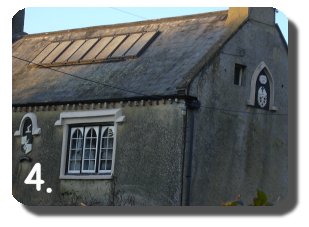 4.
Looking back at it you will see a crest with a date on it. Behind
this building and further up the slope is the Battleborough
Grange Hotel. Passing Battleborough Farm and Oakdale Beech House
on your left you emerge onto the A 38. To your left you will
see the Goat House. This is a restaurant and a shop combined.
Opposite is the garden centre of the Saunders brothers established
only a few years ago. Behind this is the M5 Motorway. 4.
Looking back at it you will see a crest with a date on it. Behind
this building and further up the slope is the Battleborough
Grange Hotel. Passing Battleborough Farm and Oakdale Beech House
on your left you emerge onto the A 38. To your left you will
see the Goat House. This is a restaurant and a shop combined.
Opposite is the garden centre of the Saunders brothers established
only a few years ago. Behind this is the M5 Motorway.
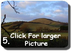 5.
Take care when crossing the A38, then turn right along the path
towards the BWOC garage. At this point it is worth looking back
at the eastern slopes of the knoll which afford an excellent
view which is much photographed. Looking north you will see
Crook Peak at the western end of the Mendip Hills which gives
spectacular views of the knoll and its surrounding land. Pass
the garage then cross the road again near the early 19th century
Fox and Goose Inn taking utmost care on this busy road, Opposite
you will see some stables. 5.
Take care when crossing the A38, then turn right along the path
towards the BWOC garage. At this point it is worth looking back
at the eastern slopes of the knoll which afford an excellent
view which is much photographed. Looking north you will see
Crook Peak at the western end of the Mendip Hills which gives
spectacular views of the knoll and its surrounding land. Pass
the garage then cross the road again near the early 19th century
Fox and Goose Inn taking utmost care on this busy road, Opposite
you will see some stables.
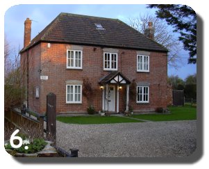 6.
Entering Brent Street you will walk under a variety of established
trees, passing the Croft on your right, followed by Croft Cottage
dated 1875. A croft was a small enclosed field or it could be
an agricultural smallholding. On your left you will come to
the white house of Athol Place dated 1884. 6.
Entering Brent Street you will walk under a variety of established
trees, passing the Croft on your right, followed by Croft Cottage
dated 1875. A croft was a small enclosed field or it could be
an agricultural smallholding. On your left you will come to
the white house of Athol Place dated 1884.
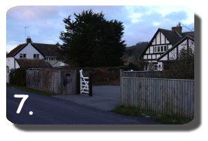 7.
Between a mixture of modern homes you will see Portland House,
The Briars dated 1688, Beggar's Roost, Warwick Court, Pear Tree
House, all indicating the original character of the village.
Behind the modern development of Portland Place you will have
another extensive view of the Knoll. Photographed at any time
of the day this will reward you for your efforts. 7.
Between a mixture of modern homes you will see Portland House,
The Briars dated 1688, Beggar's Roost, Warwick Court, Pear Tree
House, all indicating the original character of the village.
Behind the modern development of Portland Place you will have
another extensive view of the Knoll. Photographed at any time
of the day this will reward you for your efforts.
8. Just past the Post Office is the newly renovated Knoll Cottage,
dated 1900. Here you are back to your starting point.
 9.
On another occasion you may wish to do this walk in reverse
order thus giving a different perception of the area. This walk
can also be linked in with Walk Number Four. 9.
On another occasion you may wish to do this walk in reverse
order thus giving a different perception of the area. This walk
can also be linked in with Walk Number Four.
N.B. Please take the utmost care whilst walking along Brent
Street since the traffic does not always conform to the 30 miles
an hour limit.
|